
Once in a while, I come across a resource or an item so well-done, I can't help but share it. RGSrr.com is an old school site in terms of its layout and design, but one I'm very glad to count on. It has been going for years and has very handy details on the underdog narrow gauge railroad. Their work retracing route is at the end of this article.
If you have never been to see the remnants of the Rio Grande Southern, make every effort to see it sooner than later! The RGS has been abandoned for 70 years now and despite all efforts of fans and whole organizations, the San Juan mountains persist in reclaiming what Otto Mears and his partners built. Winters in Colorado are serious, but the San Juans get the most snow. The canyons are deeper, locking the snows deep late into spring and yes, even summer. One Fourth of July weekend, I was not surprised so much as impressed to find a snow and ice dam still straddling the Uncompahgre River above Ouray. Winter arrives early, stays late and works hard to break rock, timber and whatever else is in its way.
The Rio Grande Southern is not well known to many even in its home state of Colorado. By all rights, it shouldn't have existed. Born November 5, 1889, less than 3 years 8 months before the Silver Panic of 1893, it was barely off and running before it fell into receivership and out of the hands of its founder, the Pathfinder of the San Juan. It went where its namesake, the Denver & Rio Grande Western, had not dared to climb, beyond Ridgway to Telluride, Ophir, Rico, down to Dolores and Mancos and east into Durango, connecting two very distant points of the Rio Grande narrow gauge empire.
How the little narrow gauge persisted for another 60 years is a story recounted in many books, but the miracle was thankfully preserved not just in text but on film, even into the last days of dismantling by faithful friends of the railroad that connected most of the western San Juans. The spindly-legged trestles and light, narrow gauge rails made riders quail and even refuse to travel the return trip. It was built to get ore from the mines to the mills in Durango and Denver and it did, barely.
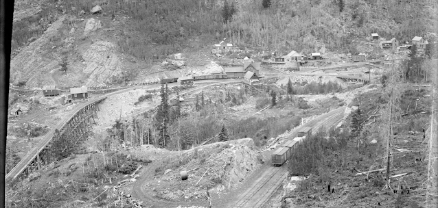 |
| In this cropped view taken from the Denver Public Library, it's easy to see how the Ophir Loop used trestle and curve, cut and fill to shoehorn a railroad through the deep canyons, climbing the San Juans of Colorado Photo: Thomas McKee |
Below, we find RGSrr.com's Route of the Rio Grande Southern. It shows with remarkable clarity, exactly where the railroad ran, how it worked with valleys and loops completed by curved trestles, fighting for every foot of altitude! It has a key that shows which trestles went where and which there are pictures for. It is an incredible resource for the narrow gauge modeler and railroad historian! ⚒

On a side note, I don't know how many times I have re-drawn or retraced the Ophir Loop on maps! And still, I've never gotten it quite right! So much of that part of the RGS was in the air, on trestles that no longer exist that it's almost impossible to faithfully recreate it in two dimension representations. That Z really does add a lot to the X, Y!
ReplyDelete